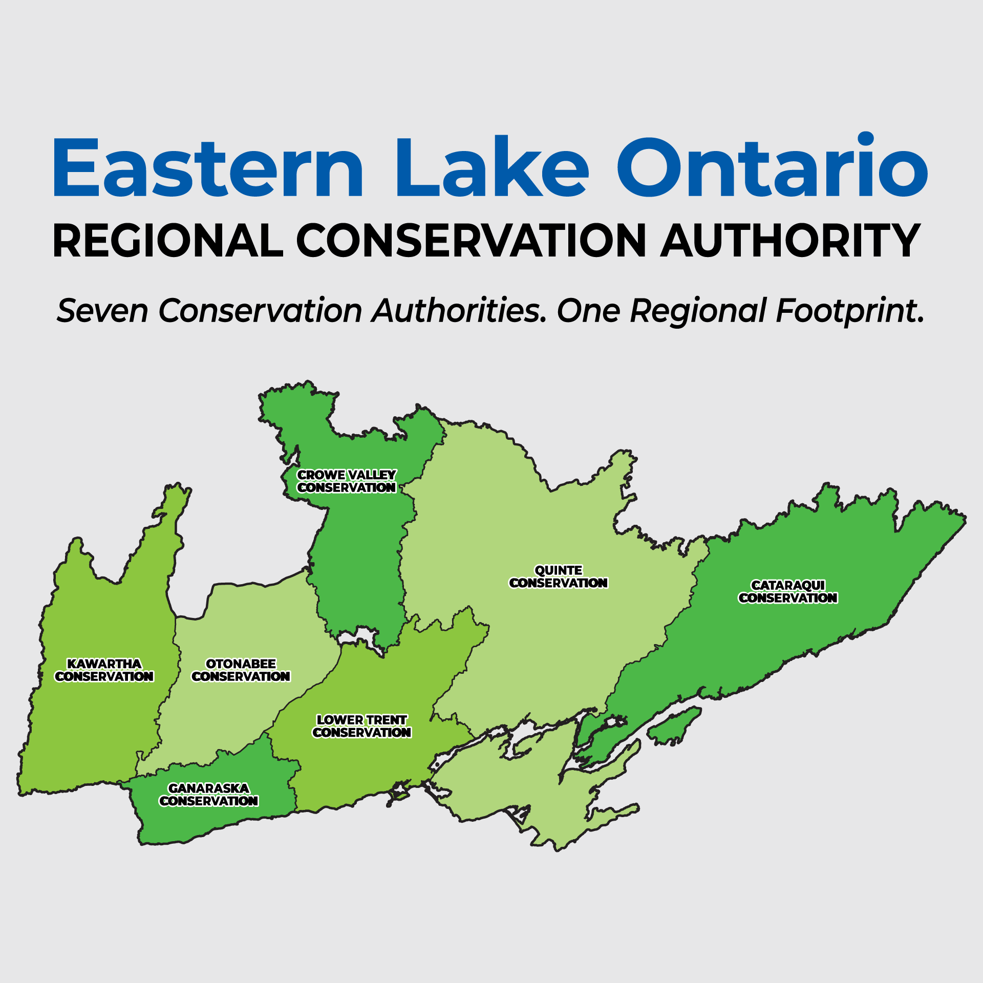
Working Together Across Eastern Lake Ontario
Ganaraska Conservation is working alongside six neighbouring conservation authorities to ensure a smooth, successful transition to the Eastern Lake Ontario Regional Conservation Authority (ELORCA).
The region brings together communities, landscapes and waterways stretching from the Kawartha Lakes south to Lake Ontario and Brockville to Newcastle. Through this transition, the seven conservation authorities are working collaboratively to bring their local knowledge, scientific expertise and experience together in support of the region and its individual watersheds.
Last Updated: October 19, 2026
Need A Service Today?
Local programs and services will continue without interruption through consolidation. Continue to contact Ganaraska Conservation for assistance as you do today.
Permits & Planning
For a property within Ganaraska Conservation’s jurisdiction, continue to contact the GRCA planning staff.
Visit Ganaraska Forest
Looking to visit the Ganaraska Forest? Please purchase a day pass or Forest membership online.
Contact the GRCA
Contact GRCA staff for information or help finding the right person to assist you with your inquiry.
A Region Connected By Water & Landscape
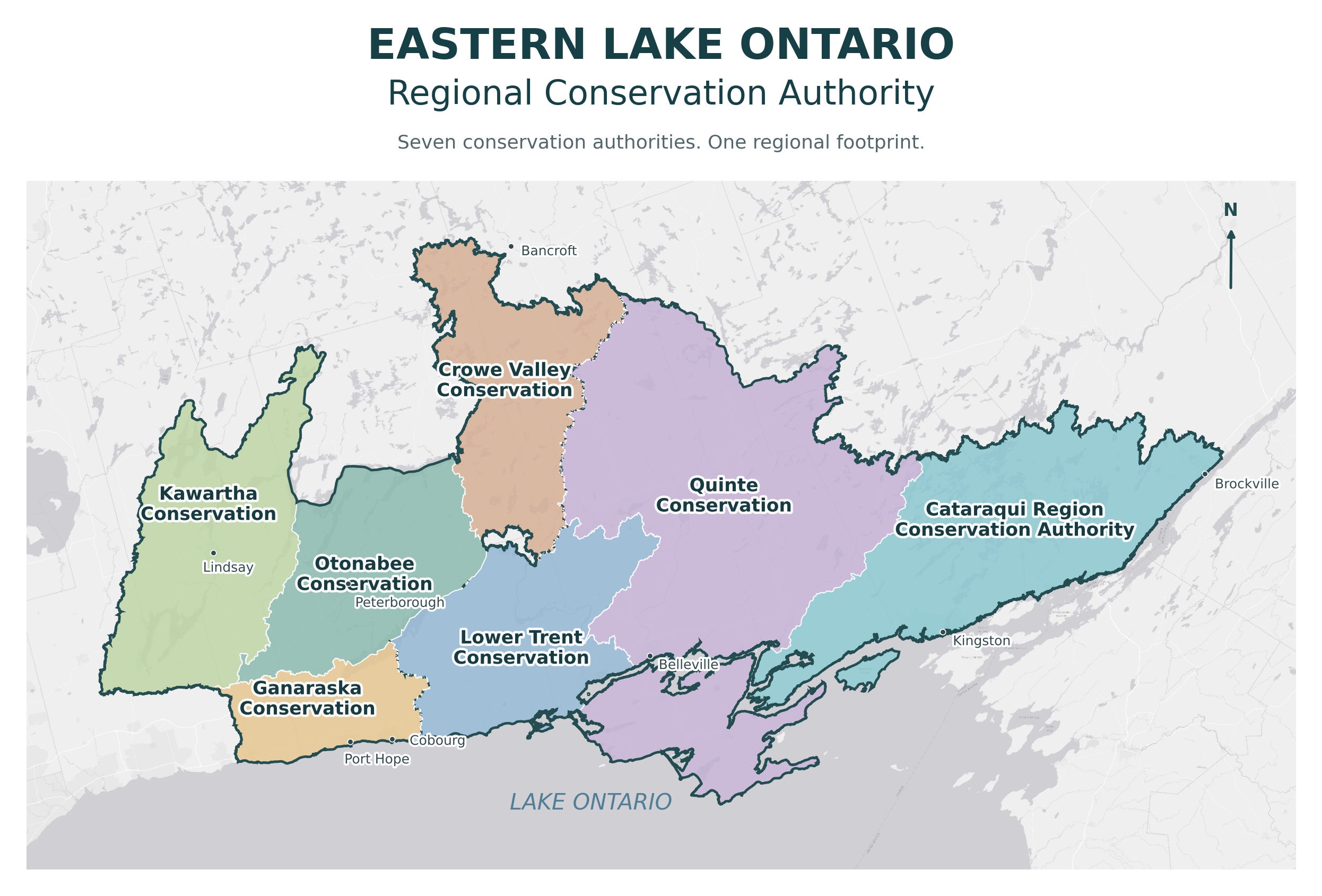
The ELORCA region extends across a diverse landscape, from the Kawartha Lakes through the Peterborough and Trent River areas, along eastern Lake Ontario and the Bay of Quinte, including through the Cataraqui area toward Brockville.
It brings together inland lakes, rivers, wetlands, forests, farmland, growing communities and shoreline environments. Across this geography, local watershed knowledge will help inform coordinated work at the regional scale.
Connected Waterways. Shared Expertise. Local Knowledge.
Water connects communities across the region. The Trent-Severn Waterway, Ganaraska River and many other waterways link communities throughout the region.
The seven conservation authorities bring experience in understanding local water conditions, managing natural hazards, protecting conservation lands and supporting watershed health. Working together creates opportunities to share knowledge, coordinate monitoring and planning, and respond to challenges that extend across existing organizational boundaries.
Regional collaboration can support a broader view of these challenges while keeping the distinct needs of individual watersheds and communities at the centre of the work.

Frequently Asked Questions (FAQ)
Questions and responses will be added as they are presented to the transition teams.
The Eastern Lake Ontario Regional Conservation Authority (ELORCA) is the regional conservation authority being established through Ontario’s consolidation of conservation authorities. It is the regional authority that will bring together Cataraqui, Crowe Valley, Ganaraska, Kawartha, Lower Trent, Otonabee and Quinte Conservation Authorities.
Local programs and services will continue, including flood forecasting and warning, permit review, stewardship, watershed monitoring and conservation area management. You can continue to access these services through Ganaraska Conservation and the local staff who support our communities. This page will provide updates on the work to bring the participating conservation authorities together.
The Government of Ontario has directed the consolidation of Ontario’s 36 conservation authorities into nine regional organizations to strengthen watershed management and provide more consistent services.
For our region, bringing conservation authorities together creates opportunities to share scientific and technical expertise, improve access to technology and resources, and coordinate work that protects communities from flooding and other natural hazards.
This work will build on the local knowledge, relationships and conservation efforts already established across the region. Local programs and services will continue, with a shared focus on protecting people and property, supporting healthy watersheds and meeting the needs of our communities today and into the future.
If your property is within Ganaraska Conservation’s jurisdiction, continue to apply through Ganaraska Conservation. Visit our Apply for a Permit page for the application process and contact information.
Our Apply for a Permit page explains the application process, submission requirements and fees. If you are at the planning stage, a pre-consultation meeting can help identify what you need before submitting an application. Contact GRCA planning staff for more information.
Start with our Search Your Property page, which links to interactive mapping showing regulated areas, including floodplains.
For questions about a particular property, contact Ganaraska Conservation planning staff.
Staff can help explain the available mapping and identify whether you should request property information or arrange a pre-consultation meeting. Checking early is particularly helpful when buying a property or planning construction, landscaping or shoreline improvements.
Continue working with the Ganaraska Conservation staff member handling your application.
If you already hold a permit, follow its conditions and expiry date. Contact our planning team before changing your project or if you need advice about completing the work within your permit’s timeframe. You do not need to wait for the regional transition to seek assistance or move forward through the application process.
Ganaraska Conservation continues to monitor watershed conditions and issue flood messages to help residents and municipalities prepare. Visit our Flood Forecasting and Warning page for current messages, explanations of flood watches and warnings, as well as information on subscribing to email alerts.
For local flood response assistance, including information about road closures, sandbagging or evacuation, contact your municipality. If someone is in immediate danger, call 911. You can also contact Ganaraska Conservation to report flooding or ask about watershed conditions.
Visit Ontario Low Water Response page for information about watershed conditions, low water levels and ways to conserve water. You can also subscribe to receive low water messages.
Ganaraska Conservation monitors precipitation and water conditions and coordinates the local Water Response Team, bringing together municipalities, water users and provincial partners to support a coordinated response. Check your municipality’s website for any local watering restrictions.
Yes, continue to contact Ganaraska Conservation for advice and support for projects that improve local land and water.
The Clean Water-Healthy Land Stewardship program includes tree planting, shoreline and erosion advice, farm stewardship and information about financial assistance through a variety of programs. The GRCA can help you explore suitable options, eligibility requirements and application periods. Contact us early when planning a project so we can help identify available support and any approvals you may need.
Continue using the Ganaraska Conservation Online Store.
Continue to use Ganaraska Conservation’s website and local office for services within our watershed. Our office is at 2216 County Road 28, Port Hope, and our main telephone number is 905-885-8173.
Current fees, forms and service information are available on the relevant service pages. Our Staff Directory can help you reach the right team member. If you are unsure where to start, call our main number and we will direct your question. Local programs and services continue during the transition.
Any donation made to Ganaraska Conservation, whether a financial contribution or a donation of land, will remain with Ganaraska Conservation and be used locally. Donations will continue to support conservation initiatives, projects and priorities within the Ganaraska Conservation watershed, ensuring your contribution directly benefits the local environment and communities you care about.
The Conservation Authorities Act defines the transition date as February 1, 2027, or a later date prescribed by regulation. We will share transition updates and progress on this page and through our regular communications channels.
Local programs and services are not changing as a result of consolidation. Continue to use the fees, office locations and contact details listed on your local conservation authority’s website.
The existing 2027 budgets are the starting point, and approved projects and funding commitments are expected to continue. The combined budgets will still need careful review, and some decisions may be needed to meet regional priorities.
The 2028 budget will be the first developed under the regional model. How municipal contributions are shared and local projects are funded is still being worked through. The aim is to keep local watershed priorities reflected in those decisions while coordinating investments across the region.
For 2027, existing funding arrangements remain in place. Projects will continue to draw on municipal contributions, grants and other approved funding sources. Municipalities will receive levy notices as they do today.
From 2028, notices setting out municipal contributions will go to participating upper-tier and single-tier municipalities. Counties and regions will have flexibility in allocating costs among their lower-tier municipalities. The details of project funding under the regional model are still being developed with municipal partners.
Board procedures and hearing arrangements are still being developed, so there is no confirmed answer yet on where hearings will take place or how residents will participate. Other conservation authorities have hearing committee models that can help inform that work.
Staff will be asked to identify plan review, permitting, hearing and judicial files. A small team will use this information to document the status of existing files and identify any matters requiring particular attention during the transition.
No decision has been made on whether the current conservation authorities will become districts, or on long-term office names and branding. Local offices and watershed connections will remain important, with a strong local presence expected on February 1.
ELORCA's identity will take shape over time, drawing on the history and expertise of the seven organizations and the people they serve. The new Board's strategic planning work will help guide that direction.
This page will provide transition updates, explain progress and answer questions about ELORCA as the regional organization takes shape.
We will continue adding information about regional governance, transition milestones and how the participating conservation authorities are working together to support local watersheds and communities. You can also follow Ganaraska Conservation’s social media channels and subscribe to the GRCA email newsletter.
If your question is not answered here, contact us so we can help and use recurring questions to improve these FAQs.
Explore the Conservation Authorities